Guides · Sanford, Florida
Reading the Buildings of Sanford, FL: A Guide
Sanford’s downtown isn’t a preserved postcard. It’s a working archive of boom, freeze, and reinvention. Read the buildings correctly, and you can trace how a citrus town became a vegetable capital, then a modern city.
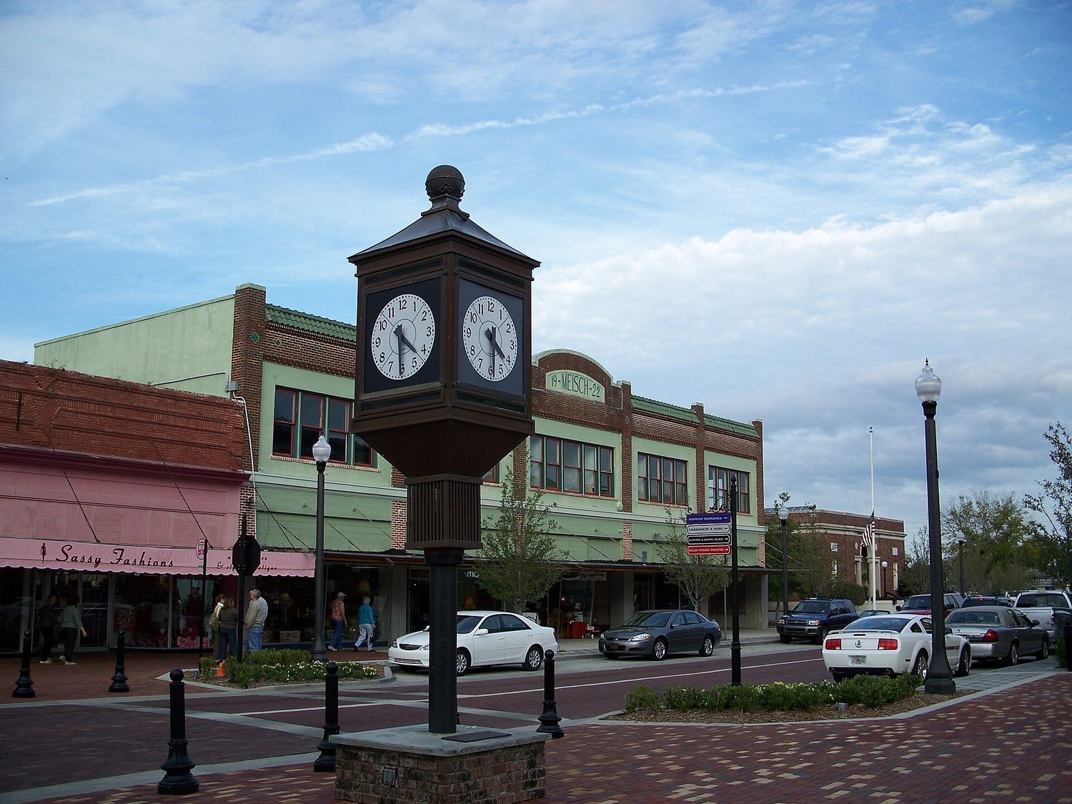
How Sanford's Street Grid Survived the 1894 Freeze
Henry Shelton Sanford bought the land west of Mellonville in 1870. When the city incorporated in 1877, the street grid he laid out became the bones of everything that followed. Six years later, Sanford annexed Mellonville, folding its older settlement into the newer plan. That grid is still the one you walk today—wide enough for wagons hauling produce, straight enough to run from the waterfront into the commercial core.
Then came the winter of 1894-95. The freeze destroyed an entire citrus crop. The growers who stayed didn’t just replant; they pivoted. Citrus gave way to vegetables, and the architecture followed the economy. The grid that survived the freeze is the same one that let vegetable crates move from packing houses to railcars without a single wasted turn.
Celery City's Commercial Architecture: A Walking Guide
By the first decade of the twentieth century, Sanford was one of the largest vegetable shipping centres in the United States. The Commercial Historic District in downtown is the physical record of that boom. The buildings here aren’t ornament for its own sake. Look at the scale: wide loading bays, deep storefronts, upper floors with offices for the brokers and buyers who ran the trade. The brick and stone facades you see were built to move celery, not to impress tourists.
The district’s layout tells the story too. Warehouses sat close to the rail lines, storefronts faced the main streets, and the whole thing operated as a machine for getting perishable goods out fast. That’s why the name “Celery City” sticks—the crop that succeeded where citrus failed left its mark not just in the history books but in the very width of the sidewalks and the height of the ceilings.
Georgetown Historic District: Sanford's Residential Side
Where the Commercial Historic District is about work, Historic Georgetown is about the people who did it. This is the city’s other historic district, and its residential architecture shows a different layer of growth. The houses here—modest frame structures alongside larger homes—reflect a community that expanded with the vegetable economy but wasn’t built around it.
Georgetown’s streets are narrower, the lots are tighter, and the architecture is more varied than the commercial core’s uniform blocks. That variety is the point: it shows a neighborhood that grew organically as workers, managers, and families settled near the downtown they depended on. If the Commercial Historic District is Sanford’s public face, Georgetown is its domestic one. The contrast between the two defines the city’s historic fabric.
From Fort Mellon to Porchfest: Sanford's Layered History
Sanford’s history goes deeper than celery. During the Seminole Wars of the 1830s, the area was the site of a US Army post named Fort Mellon. That military outpost predates Henry Shelton Sanford’s purchase by decades. When the city later annexed Mellonville, it folded that older history into the grid.
Today, the layers are still visible. The same urban fabric that held a frontier fort, an incorporated city, and an annexed town now hosts Sanford Porchfest, a free grassroots music festival on the fourth Saturday of February. Bands play simultaneously from porches across the historic residential downtown. The event is run by a 501(c)(3) that funds youth performing-arts programming and fine-art scholarships.
Porchfest isn’t a rejection of history—it’s a reuse of it. The porches that once looked out on vegetable-laden streets now host musicians. The houses that sheltered workers in the early 1900s now draw new residents and visitors. The continuity isn’t in preservation for its own sake; it’s in the way each generation finds a new use for the same buildings.
What Sanford's Census Data Reveals About Its Buildings
The census data shows what kind of city Sanford is now—and the buildings reflect it. The population sits at 62,292 people with a median age of 36.8 years, which is a younger, working-age profile. The median household income is $62,877, and 26.8 percent of residents hold a bachelor’s degree or higher. The unemployment rate is 4.5 percent, a healthy number that suggests the economy isn’t just propped up by nostalgia.
Housing tells the sharper story. There are 26,069 total housing units, but only 269 are held for seasonal or recreational use—this is a city where people live, not a vacation rental market. The 2,047 vacant units and a median home value of $272,900 point to a place that’s still affordable by Florida standards but not cheap. The median gross rent of $1,496 suggests pressure on renters, but the low vacancy rate for seasonal use means the downtown isn’t emptying out when the weather turns.
What does this mean for the buildings? The historic districts aren’t just being preserved; they’re being inhabited. The commercial storefronts that once shipped celery now hold businesses that serve the current population. The houses in Georgetown are homes, not museums. The census numbers show a city that’s stable, educated, and employed enough to keep its historic fabric alive without turning it into a theme park.
The name “Celery City” isn’t just a nickname; it’s a clue to the architecture. The 1894-95 freeze killed the citrus, but the buildings that rose in its place were built for vegetables, and they’re still standing. The two historic districts—commercial and residential—show two sides of that story. The military history of Fort Mellon and the annexation of Mellonville are baked into the street grid. And the census data confirms what the buildings suggest: Sanford is a city that has always adapted, and it’s still doing it.
Common questions
- Why is Sanford called the Celery City?
- The freeze of 1894-95 wiped out the citrus crop. Growers who stayed switched to vegetables, and by the early 1900s Sanford was a top US vegetable shipping hub. Celery became the signature crop, so the city got the nickname Celery City.
- What are the historic districts in Sanford?
- Sanford has two historic districts: Historic Georgetown and the Commercial Historic District in downtown. Georgetown is residential, while the Commercial district covers the downtown core. Both are worth walking for their architecture and history.
- Is Sanford a walkable city?
- Yes, more than most in the area. The downtown Commercial Historic District is compact and pedestrian-friendly, with shops, restaurants, and historic buildings. Historic Georgetown is also walkable, with tree-lined streets and porches, especially during Porchfest.
- What is Sanford Porchfest?
- It's a free grassroots music festival on the fourth Saturday of February. Bands play simultaneously from porches of houses in the historic residential downtown. It's run by a 501(c)(3) that funds youth performing-arts programming and fine-art scholarships.
- What's the vibe of Sanford compared to nearby towns?
- Sanford feels like the most city-like town in the region—urban, confident, and walkable, not quaint. It's more built-up than Oviedo or Mount Dora, with a real downtown grid. Day trips to those towns offer festivals, but Sanford has its own urban energy.
Every business named above is one we hold a listing for, and every date traces to a source on our sources page. We do not describe menus, interiors or service we have not verified. Details change — confirm before you travel.